

undercovergeek
-
Posts
537 -
Joined
-
Last visited
Posts posted by undercovergeek
-
-
Ingouf farm - scene of bitter fighting and coles charge:-

Uploaded with ImageShack.us
The outlying farm territories and the minor village:-

Uploaded with ImageShack.us
Northern Carentan and flooded marsh approaches:-

Uploaded with ImageShack.us
From the other side of the railway station with farming areas:-

Uploaded with ImageShack.us
Carentan's northern fringe zoomed in (included in an undulgence to myself and doffed cap to Hollywood (because i like a bit of cheese)) - the sloped entrance, the bombed house, Cafe Normadie, Hotel Ingouf, the Factory housing the sniper, the gates where Lipton was hit by the ATG, the alleyway for the ATG, the pharmacy that exploded under mortar attack, the yard at the rear of the pharmacy with the outside toilet - if i could have a piano it would be there and the chicken shed at the rear of the house on the entrance!!

Uploaded with ImageShack.us
-
Ok, map is finished (i hope!)
Now to choose the OOB and tinker with the AI - i may be here for tips
Review of the map:-
Purple Heart Lane..........

Uploaded with ImageShack.us
Flooded fields at start of Allies setup.......

Uploaded with ImageShack.us
Bridge number 4 - the start of the battle for Ingouf farm..........

Uploaded with ImageShack.us
The most Northern irrigation canal:-

Uploaded with ImageShack.us
-
Downtown Carentan now with a straight railroad and more buildings:-

Uploaded with ImageShack.us
The railroad:-

Uploaded with ImageShack.us
Close up, marshes:-

Uploaded with ImageShack.us
Hidden tracks and ditch as opposed to raised railway - the farm can now be reinforced with out Allied observation:-

Uploaded with ImageShack.us
-
agree with you both, but as you say - there will be no AFV - i can however just scrap the station, it doesnt go there, and doesnt fit on the map, i just wanted a logical conclusion to the railway that runs all the way through the map - it seemed a bit anonymous and impersonal without a station at the end - im hoping to finish the actual map today - i will look at the area where i have the station and if my town plans ligically extend into this area ill get rid of it
More tutorial reading this evening as i learn how to place units on the map etc
-
Ok - lots of progress today - effectively all done except the town:-

Uploaded with ImageShack.us

Uploaded with ImageShack.us
Bit closer - from maps and hollywood - the wall Lodz is pinned against under MG42 fire from the cafe/restaurant..........

Uploaded with ImageShack.us
.....after running down this hill

Uploaded with ImageShack.us
The courtyard behind the restaurant more of the company ran through to avoid the MG fire

Uploaded with ImageShack.us
-
thanks snake_eye - yeah it looks like the station isnt supposed to go on the map at all - ill leave it where it is - its only a tiddler adding character to the map - the rail line too is a bit of fantasy - the editor allows 45 degrees or 90 when building the tracks theres no real tool for gentle bend.
Apart from a few personal touches the map is done right upto the town border on the railway side of the map - im just adding a few touches to the fields
-
quick question - would railway lines in Normandy have been lined with fences to mark as a border or to prevent livestock wandering onto the tracks? or is the raised banking enough?
-
the old railway would have eventually been surrounded by habitation too - much as this one will be - theres houses to extend all the way to the old railway location anyway - i suppose here where it is now as well as being closer to reality it will make the fighting more intense - plus the old station was a very large metropolitan one - the real Carentan station is just a shed and some shelters and the track through - even what ive done here is an embelishment - more work tonight on what hopefully will be a fairly completed map bar the bells and whistles - then the AI
-
Ok, lets try again, please be in the right place!!
The revamped, down-scaled Carentan station, the first was a bit 'grand':-

Uploaded with ImageShack.us
Front end of Carentan (north):-

Uploaded with ImageShack.us
Map so far, to build - a hill in the southwest corner, approaching bocage and borders all the way up to the town, marsh area infront of the town and then the town itself:-

Uploaded with ImageShack.us
-
To undercovergeek,
I shall try to find something that could help you. However I don't have at the moment these documents and maps with me. If I find them elsewhere I shall post them.
The ground at the edge of Carentan was at the time full of marshes resulting in the flooding Rommel had ordered with the gates at la Barquette. The road was safe but on either side the ground was spongy. It took nearly five years from the time Carentan was liberated to dry the areas being flooded. You have to imagine that the grounds in 1944 where flooded from the road down the dead man corner all the way to the end of the causeway and on either side. That had been ordered sometimes in march or april.
I shall check that also as soon as I can.
Cheers
more designing tonight - ill post shots asap
-
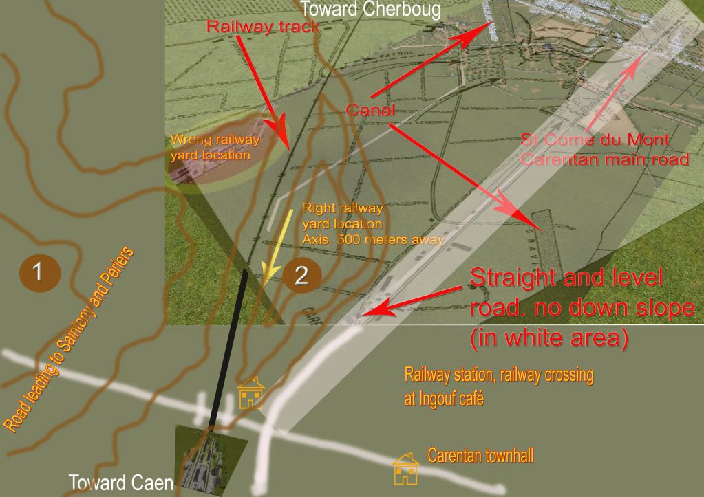
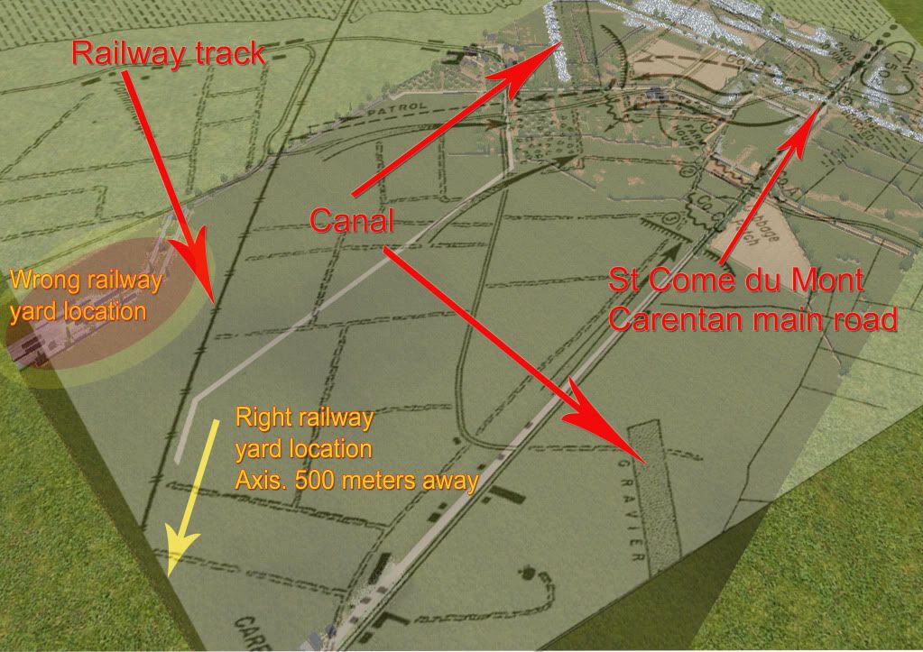
Look at the Ingouf cafe location at the railway crossroad. The station platform is on the left about 150 meters away. The yard a little bit farther down. The railway station is parallel to the road coming from St Come du Mont, after the curve starting more or less at the railway crossing.
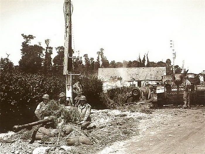
The ground on the left side (number 1) is going up till the ground is level with hill 30 ( not to be confused with the same height hill where took place the Bloody Gulch battle – on the height of Pommenaude) on the road of Carentan to Périers. There is a well known picture of that place with a US AT pointing toward Sainteny and GI’s gathered around.
The AT is sighted toward Sainteny. The SS panzer Stug III (or IV ?), seen in the back, was destroyed while retreating from that area earlier.
The ground (number 2) is forming a gentle slope. The railway track runs through it from the marshes area till it reaches a point 100 meters before the railway crossing. From there the track runs on level grounds through the railway station and from there, across the marshes found at the end of the town and that all the way to the next station toward Caen.
brilliant snake-eye thank you very much for this - do you have maps i dont or are you very familar with the area? Can you tell me if the ground is mostly marshy where you have put the number 2 symbol - i know theres marshes around the front end of the town, just wasnt clear where
it appears to me my map isnt deep enough for this without a certain level of abstraction - if i go deeper were getting up into the high squares count and i want to avoid that - so its either a very abbreviated carentan frontage (my plan all along to be honest) or some twisting of the facts - i have attempted to stay true to the countryside so far so i will put a narrow town frontage on using your details - thanks
-
To Undercovergeek
Quote //
Snake eye - im not going to disagree with a man who drives down this road everyday.......... but if you look at Jaws black and white diagram the railway line bends round in a shallow curve and comes into town well beyond the 'famous' crossroads - this concurs with the pictures i have BUT again, like i say you drive down here - let me look into it more!!
End quote//
Well you agree with what I wrote earlier. Jaws map is right, but yours is not correct for the railway station. Besides the canal on the right of the road is not shown.
I wrote you :
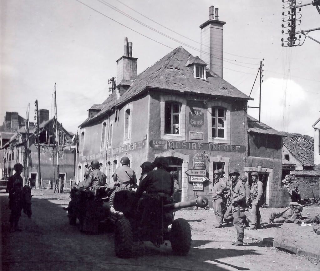
//Just, these few words, to tell you that your Railway station, besides being well done, is not at the right place. Look at the map of Jaws. The railway track merge with the road leading from the dead man corner to the center of Carentan. You have a well know picture showing the cafe standing at the railway crossing which was just before entering the station.//
The Ingouf cafe at the railway crossroad. The station platform is on the left about 150 meters away. The yard a little bit farther down. The railway station is parallel to the road coming from St Come du Mont, after the curve starting more or less at the railway crossroad.
Here after the map of Jaws put in transparency over your battle map. See the difference of location for the second canal on the right of the map and for the railway station.
Cheers
perfect snake eye - thats brilliant - someday ill have a chat with you about how you did the layover thing for future maps - man thats amazing - and my map making skills are more accurate than i thought!!

So to get this right - you come down the slope into Carentan towards the cafe, turn right, and 150 yards down there is the station and rail buildings? i have been obviously tainted by the traditional piano in the middle of the road and housing all the way down the left and right and a courtyard - as often displayed in the CoD games which im trying desperately not to recreate!
So bring the station across the top of the map until its 150 m down the road from the crossroads ive built - there will be a certain amount of abstraction as the railway stands at the back of my map but it will add a bit of character and different playing enviroment
-
Broadsword - yeah it should be ok plus the smoke wont be too much of an issue - if my reading serves me right, there were no AFVs for this battle until the counterattack
sburke - thanks for your praise, i dont know where it all started really as the 'BoB' entrance to Carentan wasnt actually the road they went in on and the little slope and the dash down to the cafe de normandie was present in COD many years before BoB but is still fairly abstracted
Snake eye - im not going to disagree with a man who drives down this road everyday.......... but if you look at Jaws black and white diagram the railway line bends round in a shallow curve and comes into town well beyond the 'famous' crossroads - this concurs with the pictures i have BUT again, like i say you drive down here - let me look into it more!!
thanks for everyones feedback
-
What's the meter dimensions of this map? Hope it will run OK.
its 948 x 1405 - works fine on my 3 year old laptop - takes about 30 seconds to load the map
-
Carentan railway station:-

Uploaded with ImageShack.us

Uploaded with ImageShack.us
Map as a whole - getting there (!):-

Uploaded with ImageShack.us
-
Ditches are great -- nice improvement. Just curious: What tile did you line the ditches with and how many meters lower than the road did you lock their elevation?
the tile is rocky - its the nearest i could get to the colourised shots of the terrain on the way into the town. The road starts at 21 and rises to 24 at the peak in the pics - the ditches are locked to be '2' below the road - where the road is 22 the ditch is 20, 23-21, 24-22 - any deeper looked like a huge crevice and the difference wasnt noticable at any other height
-
Ok - now with ditches:-

Uploaded with ImageShack.us

Uploaded with ImageShack.us

Uploaded with ImageShack.us
-
But it's the only best thing we got in how it looked back than, does anyone know what the position is in Carentan to see if it still looks the same after all those years, because i tried looking on Google Maps, but the town is heavily modernized these days.
this particular street and approach looks now like any modern t-junction in a town and there is no hill on approach, in fact it is a gentle downwards slope to a yard where the 'cafe de normandie' (not real) stood
-
Maybe use one of the roads that creates a ditch beside the roads? Seeing that was the first place Easy dropped into when the Germans opened fire. But it's really looking great, could become the nr 1 map to download and play in the future.
 If you need people to play test it before you put it out there. I'm all in.
the ditch isnt prominent enough - the only other sacrifice is to have the side of the road fall away and then rise up again but this, i think, will be represented 8 metres further away - ill mess around and have a look - that seems to be the secret to scenario design - try this, load map, try this, load map, try this, load map - i love it
-
Dick Winters and Easy Company's first view of the town outskirts - only just started here - its a bit sparse:-

Uploaded with ImageShack.us
The road looks clear for running into town:-

Uploaded with ImageShack.us
-
if the low bocage/hedge thing is that bad - the scenario designer can put 'this scenario contains no hedges' - i know i will
-
To undercovergeek
The 506 PIR was responsible for breaking through the causeway bridges (one was blown by the German retreating)., the 502 PIR being unable to carry on due to its numerous casualties. Once these objectives were overcome, they went toward the Ingouf farm and later to the hill 30 at Pommenaude to secure the high grounds.
The causeway crossing might be very difficult to duplicate for the A.I. That is if the defending German forces are well located as they were at the time. You might have 70% casualties, before getting on the safer ground at the entrance of Carentan.
More, at one time two Germans fighter bombers made a bombing run on the causeway in an attempt to blow the bridges (prior to the blowing of one of the bridge) and succeeded in inflicting huge casualties on the remaining troopers of one Company, releasing what at the time was similar to these days cluster bombs.
I think that the fight against the Ingouf farm and the one for hill 30 and its later defence would be easier for the designer to be made.
Cheers
i suppose i can only recreate the OOBs (pretending Heer are FJ for now) and place them in their historic positions around the farm and fiddle with the AI. Where scenarios go from good to great i always read about how a scenario had great surprises and really taxed the player - i want to create that feel - im yet to find out how but i will!
-
To undercovergeek,
Your work on the map is really stunning. Driving on the road close to the Ingouf farm at least once in a month, I can tell you that you are as close to reality (back in '44) that the game graphic rendering permits.
The only thing that puzzle me is the way you are going to handle the scenario of the attack across the narrow causeway leading from the dead man corner to the entrance of Carentan?. That is, if it is done in your scenario. The next assault of the Ingouf farm will be easier to manage considering the ground feature of the close area.
Bravo!
High praise indeed Snake Eye thanks very much - i want to finish the map before looking at the AI for either side, my main concern, and i will ask for advice on how to limit this, is if the Axis hit the bridge with a few mortar rounds and its destroyed - theres nowhere else to cross - great for the Axis in real life, not so great for the Allies in this game!!!
ill make ingouf farm, the village, a field with a command centre and the outskirts of town the VP areas
-
@ Undercovergeek.
Say beautiful map. just to get my bearings from some black and whites... the 2nd picture shows the Ingouf Farm House... so then to its about 1:00 would that be bridge #1 or #2?
just checking. thanks, I can not wait to upload.
Juergen.
which set of shots are you referring to GhostRider? - if you ignore the compass for the moment, the start of the map is the very north of ingouf farm and there is one stone bridge here and that is bridge number 4 - the last one they crossed before fighting in the farm grounds, then there is the farm and the small village, to be filled in is the surrounding fields and pastures and finally at the south of the map (opposite end to bridge 4) will be the town outskirts


 If you need people to play test it before you put it out there. I'm all in.


Carentan Part II
in CM Normandy Maps and Mods
Posted
Ok - first set of questions:-
1. can i bring in reinforcements based on the capture of an objective - not after a certain amount of time - the start of the battle was cole and his company (allow for some leeway here - im nailing down the OOB tonight), once the Germans were pushed past the railway line reinforcements were sent in - cue the the rest of the 506th (leeway!!!)?
2. do i need to program a German AI - it has to defend theres not much to it really - stay here and dont lose this land!
3. any links to the initial OOB and then the reinforced OOB?