

LongLeftFlank
-
Posts
5,415 -
Joined
-
Last visited
-
Days Won
15
Posts posted by LongLeftFlank
-
-
Not possible -- the AI seems to have only 2 speeds, QUICK and SLOW (crawl).
-
Yes, you need to manually add and subtract mods as needed for each scenario. I keep a folder in a different parent folder (don't put it under the Data folder) called "Unused mods"
-
There are Zero planes for a Pacific mod....
-
Couple of thoughts. 1. Try raising the banks another meter.... You need the water to be 2-3 metres below the bank to get a nice steep drop. 2. If you Adjust All to try to keep the ground level I think that raises the water base too. 3 I locked the height of the water tiles too although I don't know if that helped.
Note also that if you create a "bend" in your canal or try to run it diagonally you get some funky Salvador Dali effects on the banks.
-
Yes, I noticed this "single water table " too, although on balance it seems like it solves more problems than it creates.
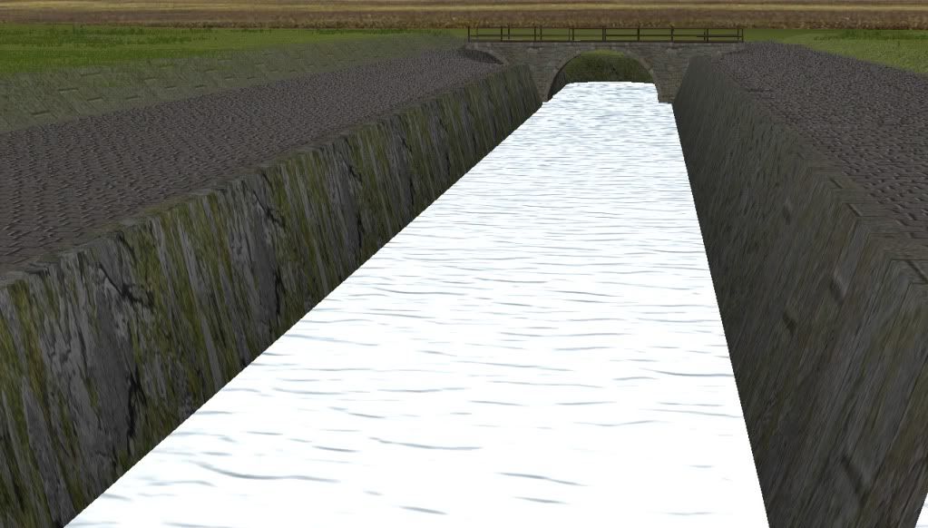
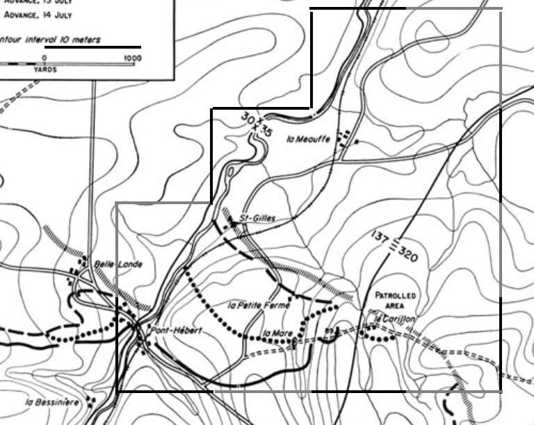
There's a weir/spillway on the Vire by La Meauffe (which was a heavily fortified position) with a couple of sturdy old watermills either side. I am currently playing with ways to depict this in the game.

The water is at height 20, road tile (weir) is at height 24, the far bank is at height 23.
And vehicles will not be able to get onto it, only infantry; I just checked.
-
Seconded! Come back safe bro!
-
From (Marine 2LT and Princeton graduate) Donovan Campbell's Iraq memoir "Joker One":
My clever plan had been to dash across the street and then leap over the double-stranded concertina wire that lined its eastern sidewalk, but I clearly wasn't thinking straight -- my vertical leap is in the single digits on a good day, and weighed down by my gear and tired out from the patrols, what little athletic ability remained wasn't nearly enough to get me over the obstacle. Running up to the barbs, I jumped anyway. Predictably, both legs landed squarely in the middle of the tangled coils of wire. Flailing frantically, I managed to free my left one immediately, but my right was caught firmly by the little razors. The machine gunner had aimed in on me now; and a detached part of my mind noticed that the concrete sidewalk in front of me was erupting in little puffs of dirt. That same part of my mind absently recorded Sergeant Leza screaming behind me, "Someone get in front of the lieutenant, goddamn it. Someone get up there."...
Intently, I focused on in on my own private battle until a sudden movement to my left caught my eye. It was Raymond. I turned my head and it seemed like I watched in slow motion as somehow he catapulted himself over both strands of concertina wire, putting his body between me and the machine gun. Then the world opened up, and I watched as the rest of his team followed his lead, vaulting the concertina wire one after the other. A solid wall of four of my Marines interposed themselves between their lieutenant and the machine gun and my Marines started firing back.
Ou-rah!
-
Been a while since I did this, and I've long forgotten, but the way I figured it out (in GIMP) was to take an existing object that had working alpha channels and edit it that way. Like the grilled balcony type.
I think it also has to do with the "number of bits" in the BMP file you save. DR how many -- the sample object should help.
-
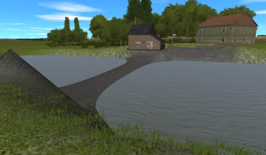
Try placing a cobbled road running right along the river. That might not get you dead vertical but should straighten out the banks. Also try playing with the elevation - a few meters will steepen the banks a lot.
Yep, it works. Vertical enough for ya?

Fix the water at level 20, fix all the adjoining squares at level 22. This shot uses the "paved 1" ground type and a "paved road 2" running parallel to the canal on either side.
-
Does he look like Burt Lancaster?

(awesome flick btw)
-
Thanks for your reply, hoolaman.
But are you sure it´s just a pavement covered slope? I´ve already tried that - and unfortunately it didn´t look nearly as great as in this screenshot. To me this looks like a vertical wall - I´ve only managed to produce slopes.
Could you please tell me if the location in the screenshot is in any scenario? I´d love to have a closer look at it.
Cheers
Try placing a cobbled road running right along the river. That might not get you dead vertical but should straighten out the banks. Also try playing with the elevation - a few meters will steepen the banks a lot.
-
Keep in mind that on a clear day, things dry out a bit and after a day or two the grass starts to yellow out and get more dusty. On the other hand, when it's rainy or misty, everything gets a lot "greener" and shinier.
-
This looks terrific -- love the disheveled faces! Also like how you took off a lot of the chinstraps. Question: is it possible to swap the peaked officers' cap for a field cap? Would love to see these on some of the officers, truck drivers, artillery crews, etc.
EDIT: on second look, one nit: the officer's caps look a little small for the heads -- I thought they were Kriegsmarine at first. Especially the guy in the background of the second screenie. The cap bill is a little off or something.
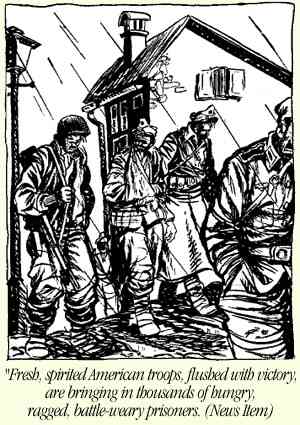
At some point I might try my hand at a "Willie and Joe" cartoon face mod, but I have my hands full right now with mapmaking.
-
Yes, I noticed this "single water table " too, although on balance it seems like it solves more problems than it creates.
There's a weir/spillway on the Vire by La Meauffe (which was a heavily fortified position) with a couple of sturdy old watermills either side. I am currently playing with ways to depict this in the game.
Also, for those interested, here's a shot of the Vire river in summer (in June '44 there would have been a lot more water in the stream. Note the fairly steep rocky banks and streambed (as opposed to marshy or muddy). A natural antitank ditch, even with no water.

-
Update: last night I laid out the footprint of the Vire river and 90% of the 10m contour lines for the 2 km x 3 km "core map". No other features yet except the La Meauffe rail depot.
-
I built the rural Gare la Meauffe station last night. No time for a CMBN screenie right now, but here's the original.

The ornate white modular building facade works quite nicely, although the "square" building type only allows you to face the roof line in an east-west orientation regardless of the building facing.
Put some pavement, a couple of benches, a barrel and maybe some crates and a farm cart, and Bob's yer unccle.
-
Cowbell. Needs more of it.
.... attached to dead cows being used as sniper emplacements.
-
-
Good thought, Pete.
I built out 4 x 4 and it takes about 8 mins to load even with no terrain. 2x3 is far more manageable so I'll start with that for the core campaign battlespace (Le Meauffe to the main road plus the Le Carillon defenses) and have built it in sucb a way that I can add enough distance in the correct directions.
For those interested, you can superimpose a grid on a source map image using the Gimp freeware program. It's a matter of scaling the image ( pixels) to a multiple of squares needed (e.g. A 2km wide map extends 250 x 8m squares)
-
In CMSF, if you have a diagonal high wall abutting a house (leaving an angle) and the door is to that side, the pixeltruppen won't go through.
-
Right, here's my proposed area pushed out another km east (4 x 4) to flange up against Broadsword's project.
Looks like our maps actually flange up pretty well at this point, B. My eastern edge seems to slightly overlap your square maps.
It isn't exact, but pretty close.
One question -- can you provide your "standard elevation"? What contour line equates to your 20m default level?
-
Good project - look forward to it. I only hope that you don't follow whoever did the Quick Maps with no idea how Normandy looked. Their idea of bocage is far too open and all their little hamlets and farms look straight from rural Kentucky circa American Civil War. This is Europe, people. Normandy. Fought over for generations, where each farm complex is a mini-fortress, built on three sides and high walled in, which is why they were such trouble to attackers. Villages are tightly-based round a village square, usually with a church, certainly with an inn/restaurant/hotel and narrow streets branching from one main thoroughfare. And bocage fields are SMALL with a lot of orchards, which is why calvados was so plentiful. They are not great expanses of cropland, either, but grazing for cattle. Which is how come every other picture from Normandy 1944 shows a DEAD COW!
Yes, the farms and towns in some of the QB maps do look a little "naked" like 1800s postcards of New England towns with only a picket fence and 99% of nearby trees cut down. My other beef is that pretty much all forests need to have an opaque wall of bushes (small trees) at the edge of them. They only "open up" once you get into the mature stands. On the other hand, some of the other maps are works of art, and I humbly abase myself before them.....
This is why I have been beating the drums for a "copy-paste" feature so that those of us who want to built copses or spinneys (can you tell I've been reading A.A. Milne to my child? -- to the devil with that Disney rubbish!) or walled Norman farms in excruciating detail down to the last rotten turnip can provide a ready made supply of templates for those who prefer to focus on the OB and the AI plans.
-
LOL! Steve has indicated that a more "granular" look at building damage and demolition is fairly high on the list for future development.
-
Longleft,
We should definitely cooperate, because we share exactly the same philosophy about mapping and historical fidelity, etc.
My longterm project fits pretty well alongside yours, because here's the AO I had marked out to work on:
I found that the area from the Vire River east to the St. Lo-Bayeux highway falls pretty well into a 2km x 4 km map and two 4 x 4 maps. Your Carillon area would be within that 2 x 4 km area, so I'll concentrate on the 4x4 areas. That gives us the entire area where the 35th ID (and a little of the 29th) faced the German 352nd ID from July 11 until St. Lo fell.
If you're interested and want to try and have your E edges match up (at least approximately) to my W edges, the GPS coordinates of my map boundaries are as follows:
For the 4x4 map on the upper right:
NW corner:
Latitude 49.180033
Longitude -1.086301
SW corner:
Latitude 49.144603
Longitude -1.100560
For the 4x4 map at the bottom (the one with St Lo in it):
NW corner:
Latitude 49.146944
Longitude -1.114207
The corner where the N edge joins the SE corner of skinny map:
(same coordinates as SW of previous map)
Like you, I may be ready for eldercare by the time it's finished -- especially because I see I'll be enjoying just playing CMBN for quite awhile. I may also wait a bit for some tips and tutorials to come out to make the map editor a bit easier to use -- I'm sure the community and BF will explain a lot more about how to use it as time goes on.
Finally, please let me know of any other good mapping resources you find for these areas. I've already used the French 1947 aerial photos, and found some AAR maps, but it's always good to share sources.
Sir, I am definitely all over this idea. I will send you a PM with my email address and we can coordinate!
Also, looks from your screenie like I need to recheck the scale units on the map I posted in my OP..... might have used the wrong yards to meters conversion factor. :*)

AI Patrol
in CM Normandy Maps and Mods
Posted
No. CMx2 isn't really designed to support partisan or behind-the-lines type actions. All AI troops are assumed to be "at the front" and keenly aware of that fact. Hence the "dashing" or "crawling" default behaviour.
The only exception is if the AI troops are Exhausted; they will then MOVE (walk) instead of QUICK. So if you really really really want a patrol to walk instead of running, you might try giving them a heavy machine gun or sumfink, have them FAST or SLOW up and down for a while until Exhausted and then send them on their way.