

LongLeftFlank
-
Posts
5,412 -
Joined
-
Last visited
-
Days Won
15
Posts posted by LongLeftFlank
-
-
Yes, a sandbagged and fortified building... Ground at least, would seem essential
-
Thanks for the help and suggestions, all. Work is busy this week but I hope to look at it again this weekend.
-
Argh! The muttonheads who made the Green Book map I showed in the OP mixed up feet and meters when they did the altitudes. The detailed 1951 map (a copy of a German Heer map) and Google Earth both agree -- all my contour lines are worthless. Have to start over again.....
-
Thank you Comrade Stalin.
-
For the record, I too believe the interface needs to be substantially streamlined to minimize clicks required to issue the most common commands in RT play.
Also, while I get that a "Show All Target Lines" toggle isn't relevant to the CMx2 engine any more, that was a great way to show you at a glance where the action was heaviest and which units needed micro. Just having the icons blink momentarily when a unit takes a casualty simply isn't enough when trying to manage a company in RT play. Blink and you miss it.
While I'm not underestimating the programming complexity, resource "drag" or aesthetics issues of "animating" icons, something minimally intrusive like the following would dramatically improve playability:
(a) Unit is stationary, with no orders: default icon (square or circle)
(
 Unit is under orders: "squeeze" icon (slightly taller than it is wide)
© Unit is Moving: "italicize" icon (trapezoid or 0)
(d) Unit is firing/aiming: "flatten" icon (slightly wider than it is tall)
(e) Men are Cowering or vehicle has received a shell hit: "negative" icon (light figure against darker background)
(f) Unit has taken a Casualty or AFV being abandoned: blinking icon.
Or sumfink....
-
Me too, actually. Even with no trees, bocage or defenses in there yet, just by surfing the bare contour map I'm already getting a sense of what a daunting attack this was for the Santa Fe Division, and how the Germans could hold this position so strongly with just 2 depleted fortress battalions.
A 70 meter altitude change doesn't seem like much over 3km, but it's enough to give good overwatch. And the Vire river and fortified hamlets anchored the German left flank very strongly. So the Yanks had little choice but to slog directly across country into that famous Le Carillon map with all the little arrows (MG nests) on it. Which I will be recreating down to the last detail....
P.S. And on our good neighbour and ally's Memorial Day, it is fitting to take a moment to recall the good soldiers of the 137th Infantry Regiment and supporting units who fell fighting for this 3km x 4km patch of farmland north of St Lo from July 10 - 19, 1944.
Killed.....: 1 12 7 21 17 16 5 13 11 9 = 112
Wounded: 2 96 74 87 106 100 23 61 57 11= 617
Missing...: 0 18 7 17 4 1 2 6 7 1= 63
792 casualties in 9 days. That's over 50% of an estimated initial regiment frontline combat strength of ~1500.

-
The "Funnies" will be in the final module IIRC
-
Nahh...he's been riding around with his head out the hatch catching bugs and dust with his face...plus there's no way to differentiate the tankers from the infantry.
Mord.
Agree! Fighting a tank is dirty work, especially after shooting a bunch of rounds buttoned up.
Nice work bro! This will become part of my standard modset.
Love to see some grimaces or at least squinting in addition to the generally deadpan expressions... like that one ugly Syrian.
-
Two more? I'd want at least 20 for a two company sized action!
I'd also like to see a slight bias of units toward destination squares that are nearest their current Locations. In other words, if Order 1 has my AI Group move to phase line Red and Order 2 has them move to phase line Blue, I don't want them zigzagging across the entire line of fire because their destination was randomly selected.
-
In contrast, I would have thought the little village churches would take more punishment though -- the walls anyway. While not as thick-walled as the urban cathedrals, they do date from medieval times and are stoutly built of field stone.
-
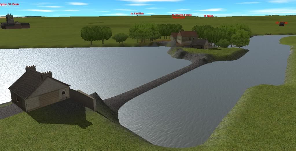
And here's the only spot I've done in any detail; the watermill near St Gilles.
-
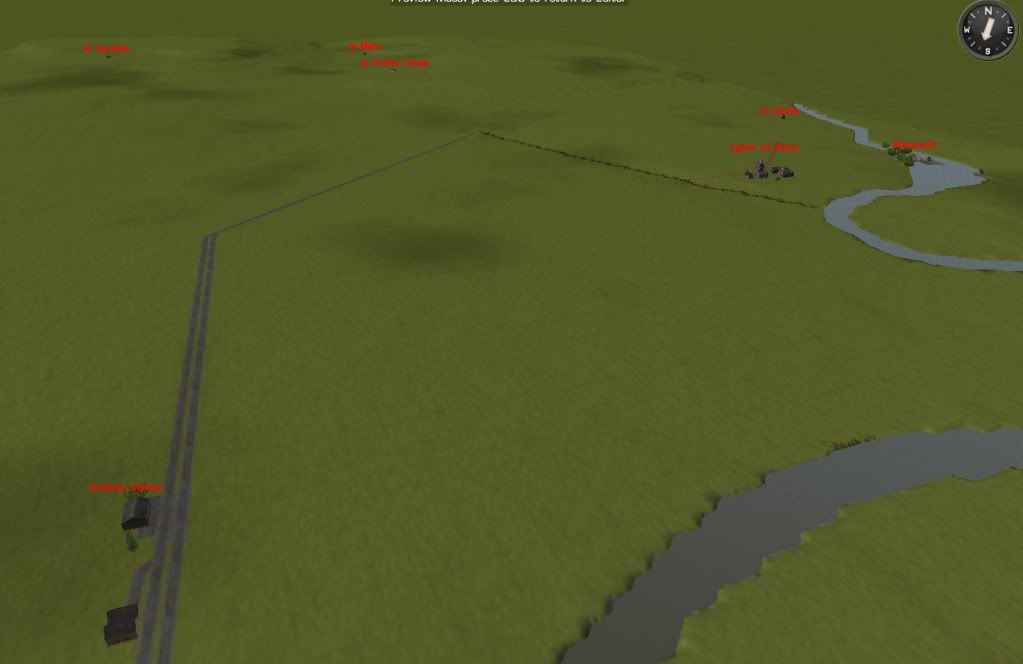
For those interested, here's an early shot of the 137th Infantry's front (2.5km) on 11 July, with the key German positions marked. Not much detail yet but the general contours are done and you can see how Le Carillon (far left -- sorry the pic is fuzzy!) dominates the map. The map is also cut by a number of wooded draws containing small creeks that drain into the Vire; these will be tactically critical, as will be the sunken roads and the railbeds.
-
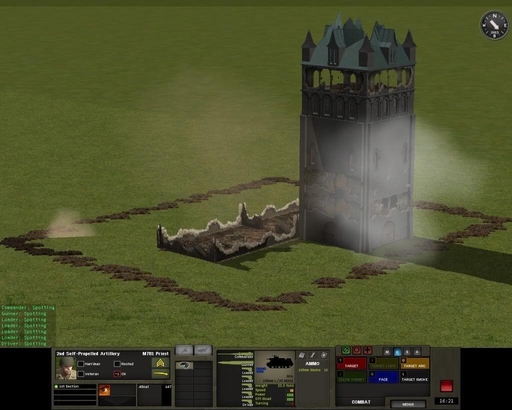
I repeated the same test with the large 3 story rectangular church building. It didn't even show light damage until minute 5 and hadn't sustained any worse by the time the M7s ran dry. In contrast the surrounding walls were 100% shattered even though they weren't directly targeted.
-
To test the resilience of the Cathedral tower, I had it blasted nonstop by a pair of M7 Priests, and it proved equal to the challenge.... 110 rounds of 105 HE direct fire targeted on the second floor and it was still standing after the Priests ran dry (14 minutes in). (they aimed at the top for the first minute, creating the damage up there -- the shooting was accurate).
In contrast, the single story church buildings adjacent to it were both destroyed by collateral damage from a single shot in about minute 5. The surrounding high stone wall also vanished by the end of the bombardment.
FYI.
-
Yes, in CMSF, the HQs and MG teams were DEFINITELY the last to move in each sequence. But because the destination for each unit for each AI movement command is randomly selected from among the various destination squares, they might well seem to be ending up at the "tip of the spear" a lot of the time.
Which in WWII isn't as unrealistic as it sounds. C2 wasn't as big at platoon level as it is today, and subalterns on both sides were expected to "lead from the front", or at least had the idea that they did. The old cavalier tradition hadn't entirely been beaten out of armies by the WWI carnage, even though the sabres and horses had long gone by the wayside. Hence the disproportionately high casualties among lieutenants and captains.
-
No, i think he means certain building layouts are only available in the 45deg version but not the 90deg. He wasn't asking for odd angles.
-
Great work on this; looking forward to seeing it!
-
My sigline below has a direct link to GreeAsJade's site, but it's also in the Repository under the CMSF scenarios. If you're talking about the full size map, I haven't released that.
-
LOL! Gateway to the Reich....
(although Farmer Picky would like to point out that most Norman cattle didn't have the classic Holstein pattern).
-
You could also start the troops in the backs of (partly sunken) halftracks that are turned around backwards. That way, you'd also have the covering fire from the "LCVP" gunners. On the other hand, it might just look silly and spoil the effect.
I also find myself wondering if there isn't a way to mod some kind of long grass or grain so that it's white and stick it in the water in a high wind so its waving looks like whitecaps and moving surf.... Just a thought.
-
Wait Mord, what you just said could be misread. You mean the game will prefer the files that are sitting in the (sub)FOLDER with the highest letter.
If you change the names of the FILES (except in a few cases like building or face textures where you can add "1" "2" etc.), the game will simply ignore them entirely.
-
No. CMx2 isn't really designed to support partisan or behind-the-lines type actions. All AI troops are assumed to be "at the front" and keenly aware of that fact. Hence the "dashing" or "crawling" default behaviour.
The only exception is if the AI troops are Exhausted; they will then MOVE (walk) instead of QUICK. So if you really really really want a patrol to walk instead of running, you might try giving them a heavy machine gun or sumfink, have them FAST or SLOW up and down for a while until Exhausted and then send them on their way.
-
Not possible -- the AI seems to have only 2 speeds, QUICK and SLOW (crawl).
-
Yes, you need to manually add and subtract mods as needed for each scenario. I keep a folder in a different parent folder (don't put it under the Data folder) called "Unused mods"
 Unit is under orders: "squeeze" icon (slightly taller than it is wide)
The Carillon Nose (137th Infantry) - Campaign In Progress
in CM Normandy Maps and Mods
Posted
My plan is to release the big map of the 2.5 wide x 3km deep battleground of the 137th Infantry (basically the east bank of the Vire from Le Meauffe to the Pt Hebert-St Lo highway) for anyone and everyone who wants it for whatever.
For manageability the "master map" will be nearly devoid of vegetation, and will contain the Vire River, the contours and gullies, the road and rail net, and the major settlements/ buildings. The outline of the fields and forests will be mapped out using placeholder terrain.
Scenario builders can then easily fill in the bocage and trees and doodads once they carve out the submaps (which is simply a matter of shrinking the size of the map to fit the specific battle).