

simovitch
-
Posts
277 -
Joined
-
Last visited
Posts posted by simovitch
-
-
rune, if your still following this thread...
From the "topographic maps of italy" thread in the scenario talk forum, I was able to get a great view of San Pietro Infine at 1:25000, probably wartime-period with (contemporary) aerial overlay. Its right up on my screen - beautiful... but I can't for the life of me get a hardcopy, so no screenshot. :mad:
If you can manage to get into the map site, its on the "Lazio" portion of Italy, at coordinates:
Top left: x-412961, y-4589507
bottom right: x-414904, y-4587968
hope this helps.
-
rune,
Send it over to me at my email adress, I would be honored to have a look. With ROW V about to start, It may take a while if it's a PBEM. if I can play it VS the AI (default setup?) I should be able to hammer it out in less than a week and get you an AAR.
thanks,
-
J2D lol! sorry for sending you on a hypothetical reference goose chase.
If you spell gnep backwards you would get "Hi Mom".

Anyway, point well taken rune. And If there is a disclaimer with the scenario, I do appreciate it. Beside my desire to vent, my main question though is if anyone shares my historical OCD with any certain scenario that they have played in CM.
cheers
-
I need to share a pet peeve.
Let's say you are a long time student of the history of the "schmegg offensive". You know the terrain quite well, you have photos and period-mapping information. You know the OOB of the battle and have a good idea about the TO&E's of various units at various times during the campaign.
Not uncommon I would say for this group.
Then you find a long awaited scenario covering one of your favorite battles during schmegg: the "battle of gnep". It's listed as "historical" and the breifing is right on.
Then you open the map and it's at best a 2004 mapquest rendition. The topography and tree coverage is pure fantasy...
Then to your added dismay the OOB gives you a couple of "wombats" to lead the charge, when you know quite well that even though the hollywood version showed Macauley Caulkin leading a troop of wombats into battle at Gnep, you know without a doubt there were no wombats at Gnep, or anywhere in the schmegg offensive.
Like myself, do you find it difficult, if not painful, to play that scenario? This happens to me so many times (not always) in CM that I am starting to feel a little dismayed. The main reason I bought this game was to get play (and develop) some faithful reconstructions of the schmegg offensive battles.
-
How about "mounted fire" from Halftracks and tanks? and if you mention horses you gotta wonder where are the reindeer... and puulka's?
-
llama,
That one was a tough scenario as I recall, and the only way to win really is to get your tommies into the town in force without getting them killed crossing the fields.
As I recall, you got plenty of mortars and OBA. Get as close to the town by working your way through the woods and then lay down a blanket of SMOKE, and keep it up until you reach some buildings. Good timing is essential here.
I would say use at least 85% of your artillery assets for SMOKE.
Keep your armor out of View of the Panthers, use your AT guns to keep them busy, and your infantry to distract them. bring them out in the late game when the Panthers are distracted. Dont expect your armor to hold any flags. That will be the job of the infantry.
Hope this helps.
-
Absolutely stunning resolution at 1:25000, and aerial overlays to boot. This is an awesome resource for map makers. However...
no comprendo el printo le hardcopyissimo.
-
Tarkus,
thanks, that is a good answer.
Now to order those 1:50000 1944 US Army topo's of the Belgium Ardennes out of the UC Berkeley storage archives and wait "it" out :cool:
uh... The first "it" better be WWII western front :mad:
-
"because CMx2 games won't contain hand crafted scenarios"
huh?
"The only way to avoid that is to eliminate Quick Battles and the Editor, which I am sure you guys don't want"
uh... huh? ok. I remain cautiously optimistic.
-
This is from the Bones thread. It implies that there will still be a map editor but we won't be able to design our own buildings.Originally posted by simovitch:</font><blockquote>quote:</font><hr />Originally posted by CSO_Talorgan:
</font><blockquote>quote:</font><hr />We are looking into ways of allowing people to add customized skins for objects on a scenario by scenairo basis. It won't allow for customized building shapes. Too early to say if this will happen or not as it is still on the "if we have time" list.
Doing away with the map editor is just too appauling to contemplate. </font>
-
double post deleted
[ January 25, 2005, 01:13 PM: Message edited by: simovitch ]
-
I've searched the threads a bit and I still can't establish whether or not CMX2 will have a map editor and allow 3rd party scenario designs.
Please excuse me if what at face value this seems like a silly question, but it seems like Im seeing only "in the can" scenarios will be available, but the terrain "tiles" will be smaller.
I want to do historically time-period accurate (both horizontal and vertical) terrain representations for CMX2 and I love the idea that the tiles will be smaller...
but will I be able to make my own maps in CMX2?
simovitch
-
in america we call that a brain-fart.
sorry Timo.

-
Thanks for the endorsement Pasi. I made my share of mistakes in Tali though. I think a rhesus monkey could have done just as well given the forces involvedOriginally posted by Larry Thorne:Hi
I was forced to throw in the towel at battle 2 after my Awesome opponent Simovitch steamrolled over my brave Finnish fighters in Tali Operation. -LT
-
Nice work Almaniac.
I wish others would care so much as to represent accurate vertical relief with their "historical" scenarios.
Good quality topo is not that hard to get ahold of for most people, and using it to generate an accurate map with accurate vertical relief should be as important to the designer as historical TO&E and an accurate breifing, imho.
"McAuliffe" has a good mapping tutorial as well, still found at his exceptional site here
-
Good stuff buq buq, thanks for the clarifications.

-
The caption under this photo from Hugh Cole's "The Ardennes: The Battle of the Bulge" Chapter 6, reads:
"WRECKED GERMAN TANK SHOWING "BAZOOKA PANTS," a defense against rockets"
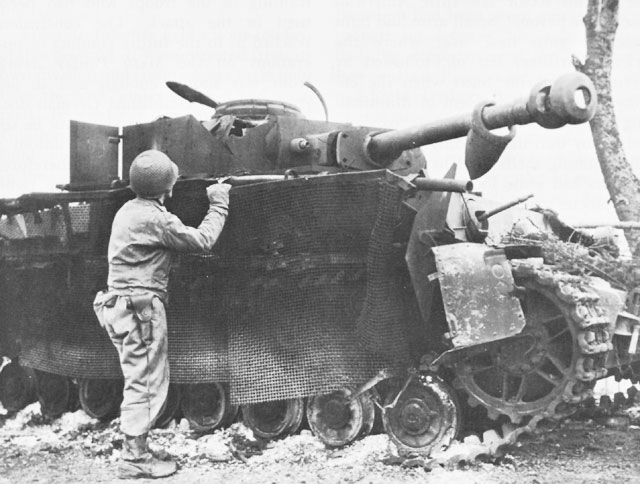
Apparently at least by the end of 1944 the Germans were investigating some aspect of the "skirt" protection against shaped charge weapons. Note that steel mesh is used in lieu of plating. Hardly the choice material for protection against small arms fire.
-
The "skirts" were also effective in reducing the effect of high explosive anti tank (HEAT) rounds on the main armor, namely that which is fired from a bazooka. The pre-detonation of the HEAT shell casing on the skirt diminished the penetration ability of the remaining shell core, or something like that.Originally posted by Mattias:Personally I think they might not have been deemed absolutely necessary as the 40 mm armour they protected was a bit on the thick side for ATR:s (skirts originally being fitted as protection from, primarily, ATR:s).
M.
Does anyone know whether or not the application of "skirts" on an AFV has been modelled in CM?
-
For anyone who cares, It was during the first days of this battle that Eric Fletcher Waters, Roger Waters (of Pink Floyd fame) father was killed.
"When the Tigers broke free"
It was just before dawn
One miserable morning in black 'forty four.
When the forward commander
Was told to sit tight
When he asked that his men be withdrawn.
And the Generals gave thanks
As the other ranks held back
The enemy tanks for a while.
And the Anzio bridgehead
Was held for the price
Of a few hundred ordinary lives.
And kind old King George
Sent Mother a note
When he heard that father was gone.
It was, as I recall,
In a form of a scroll,
With gold leaf and all.
And I found it one day
In a drawer of old photographs, hidden away.
And my eyes still grow damp to remember
His Majesty signed
With his own rubber stamp.
It was dark all around.
There was frost in the ground
When the tigers broke free.
And no one survived
From the Royal Fusiliers Company C.
They were all left behind,
Most of them dead,
The rest of them dying.
And that's how the High Command
Took my daddy from me.
I doubt there were Pz VI's in the vicinity, but it makes for a great song title.
-
For the longest time I couldnt figure out why what appeared to be a supersonic swarm of bees kept flashing across my screen
:confused:
I finally guesses that it was canister shot being fired.
Probably not what you are experiencing, but a heads up for the noobs.
-
Co. C, 51st Engineer Combat Bn. at Trois Ponts and Co. A, 291st Engineer Combat Battalion at Habiemont, Belgium.
Platoon sized elements of both companies were responsible for halting an entire reinforced Panzer Regiment (Kampfgruppe Peiper) during the Ardennes Offensive.
-
All this anticipation reminds me of the '70s when I waited for the release of AH's "Panzer Leader", which touted big refinements over "Panzerblitz". :eek:
Like then, I just can't wait!
-
I bought CMAK:
1. To experience the Western Desert on a tactical level. It's quite the challenge to seek out small undulations for cover at level 1 on a well made map.
2. hoping that it can be modded effectively and realistically to Northwest Europe.
so far, so good.
-
You actually have a topo, so you are miles ahead of alot of "historical" map designer's already. Incidentally any map scale over 1:50000 and you may as well fuggetaboutit.
draw a 100m X 100m grid, scan it, and print a large version out so you can transpose the map manually into the CM editor wihthout going blind.
I use Autocad to bring in a hi-res scan, and grid it with fine gridlines and print it to my printer. Sketching the "contours" in the Map editor takes a steady hand on the mouse and a lot of patience, but it's worth it.
Ive never tried mapping mission, am I really missing something?


ahistorical dilemma
in Combat Mission: Afrika Korps
Posted
someone in the thread said he used "screenprint32 v3.5 and it saves it pretty good."
does anyone know if screenprint32 is freeware or feeware?