

sawomi
-
Posts
376 -
Joined
-
Last visited
-
Days Won
1
Posts posted by sawomi
-
-
Theatre Europe (C64) -> Red Storm Rising (C64) -> Battle Isle games (Amiga) -> Jagged Alliance (PC) -> Steel Panthers II: Modern Battles (PC) -> Close Combat: A Bridge Too Far (PC) -> Combat Mission: Beyond Overlord [beta] (PC)
-
-
Thank you very much.
-
10 hours ago, The_Capt said:
...you guys want to see shots of German countryside?
Yes. Especially some Brick Gothic.
-> https://en.wikipedia.org/wiki/Brick_Gothic
-> https://en.wikipedia.org/wiki/List_of_Gothic_brick_buildings_in_Germany
-
Quote
...In der Nationalen Volksarmee der DDR wurden 1964 die T-34/76 ausgemustert; die letzten 35 Panzer T-34/85 mit der 85-mm-Kanone blieben dort bis 1988 in der Reserve oder wurden auf Schießplätzen als Hartziele verwendet. ...
https://de.wikipedia.org/wiki/T-34
translation:
In the National People's Army of the GDR, the T-34/76 were retired in 1964; the last 35 T-34/85 tanks with the 85-mm gun remained there in reserve until 1988 or were used as hard targets on firing ranges.
-
That's why I linked to the German wikipedia page. It has a map:

-
Highway strips must at least be taken into account in the calculation.
-
-
Thank you very much.
-
disappointing, no Germans...
-

I found it on my disk and uploaded here:
-> https://www.mediafire.com/file/4rbjt9j04ityfp8/MikeyD_CMBS_sunflower_crop_6_mod.rar/file
-
Now updated to v2.
Attention: rar is 256 MB - unpacked .brz file is 675 MB !!!
Content: War in Ukraine/Donbas/Novorossiya 2014-2022
-> https://www.mediafire.com/file/92p879j8uxdun46/cmbs_sawomi_force_backgrounds_v2.rar/file
Download, unpack and put the .brz in your ...mods/Z folder
-
11 hours ago, Hacketäuer said:
To have the NVA would be great. Those helmets for me epitomize the cold war.
They where developed in the 3.Reich as M45 / Type BII (prototype was registered as patent on December 7, 1943), but only testet in combat by the Wehrmacht in small numbers (picture from September 1944, Westfront):

source: https://archive.org/details/DieDeutscheWochenschauNr.733 (Minute 5:48)

In GDR M45 was then improved to M56 NVA version.
-> https://de.wikipedia.org/wiki/M45_(Stahlhelm)
Supposedly, before the introduction of Kevlar helmets, they had the the best ballistic protection and earshot range.
Would be cool if this could be simulated in CMCW. (like very small percentage increase for shrapnel protection and command audibility range).
-
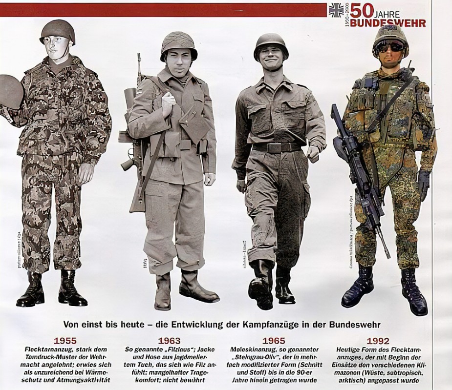
22 hours ago, Gary R Lukas said:
Fleck-Pattern Camo
Bundeswehr Flecktarn was introduced on a unit-by-unit basis as of 20 February 1991.
-
Ukraine
31 minutes ago, Haiduk said:...nobody from our serious historians doubt that "Ukraine" is derived from Ancient Rus word "oukrayina, ukrayina" - "frontier, border land". There is nothing splended in this derivation. This is just objective fact. First mention of word "ukrayina" we can find in Ipatyevska chronicle under 1187 year, but this name related to Pereyaslav Principality. Pereyaslav - the town in nowadays Kyiv oblast, which in that times, was a center of separate principality, which was real frontier with Wild Steppe and nomad tribes.
When modern Ukrainian lands in 14th century became a part of Great Lituanian Principality, already Lithuaninan rulers named old Rus lans as "ukrayina" - "Kyivan ukrayina", "Volynian ukrayina" etc, with the same sense - "frontier lands". Further theese names often mentioned in Polish-Lithuanian Commonwealthm. Active mastering of Wild Steppe in 16th century and rising of Cossacks gradually has been fixed "ukrayina" for lands on left bank of Dnieper with Kyiv and Cherkasy regions, and since the mid of 17th century this name was extended on whole Cossak-controlled territory.
It seems to mean, what in German is a 'Mark', like "Mark Brandenburg". The equivalent English term would be a 'march'.
-
2 hours ago, Aragorn2002 said:
Biden has said that Zelensky ignored his warnings about the coming invasion of Ukraine by Putin. That statement wasn't well recieved in the Ukraine. Why did Biden say this? And why now? ...
->
-
also uploaded at The CM Mod Warehouse:
-

Loading screens for Combat Mission Black Sea. (the pic above shows only some examples out of over 200)
Attention: rar is 182 MB - unpacked .brz file is 474 MB !!!Content: War in Ukraine/Donbas/Novorossiya 2014-2022
-> https://www.mediafire.com/file/hf7kkglyaq3x6b2/CMBS+sawomi+Force+Backgrounds.rar/file
Download, unpack and put the .brz in your ...mods/Z folder
------
I also made similar mod for Combat Mission Cold War :
-
16 hours ago, Weezkee said:
...tape around the helmet? I've been struggling with that myself and didn't manage to do it so even.

This is the (suboptimal) result of my efforts I made for my personal mod-collection. I have attached the png file for the helmet tape.

-
-
On 5/10/2022 at 3:00 PM, Free Whisky said:
This a very detailed answer to the question what the battle would have looked like
 .
.
Also interresting about it is that the assumption of the Soviets was that NATO would be the agressor.
You have to understand that after May 1987 Warsaw Pact officially changed it's whole military doctrine to purely defensive - not only in 'intent' - but also in strategic operational implementation. That means no more 'defensive through attack'.
Conventional World War 3 would have been fought on GDR-territory from this point on.
So, no 'Fulda Gap 88', 'North German Plain 89' or 'Danube Valley 90' pseudo-'historical' scenario after May 1987! (if we believe historical records.)
That means any computer game with a 'Cold War 1989 Warsaw Pact attack on Western Europe' setting is just pure fantasy. It's NOT 'pseudo-historical'. Its -Just.Pure.Fantasy.
Like 'Nazi Wehrmacht 1946' or the like.
Only if NATO had attacked GDR, 'Operation Zentrum' would have been executed.
Of course, there where plans before that by Warsaw Pact to occupy West Berlin, but about those we have not the 'exact' details that we have about 'Operation Zentrum', as far as I know.
But, then again, these pre 1987-plans would have been not THAT much different, of course.
So the 'data' we have about Operation Zentrum can be used more or less also for pre-1987 West Berlin scenarios. At least in the 'broad strokes'.
-
The map was created in 1990s according to the records and information of a former officer of the NVA and shows how Operation "Zentrum" (='Center') was planned in detail (from 1987 on).
Objective:
After NATO has carried out its aggression and crossed the GDR's state border, the "Berlin Grouping" makes a lightning advance to the Kaiserdamm Bridge. Paralyzing the "communication and political power centers" of West Berlin and blocking the barracks of the Allied protective powers.
By the end of the day, West Berlin was to be divided and occupied.The urban area of West Berlin was divided into two zones of action (Sector I +II).
The border between the sectors runs at: Konradshöhe, Hohenzollernkanal, Westhafenkanal, City highway ring between Freeway junction Charlottenburg and Freeway interchange Schönberg, Suburban railroad line between Papestraße and Lichtenrade.
Main push direction: From west -> Heerstraße. From soutwest -> the Avus ('Automobile traffic and training road'). From east -> Straße Unter den Linden and Straße des 17. Juni.Implementation:
At night taking of Tegel and Tempelhof airports by I. Battaillon of Luftsturmregiment 40 "Willi Sänger" from Lehnin.
With the beginning of the attack blasting of about 60 "alleys" through the Berlin Wall.
Sector I:
- Leadership: 1. Mot.-Schützendivision [1. MSD] NVA (without Mot.-Schützenregiment 1). Command post in expanded basement facility in Stahnsdorf.
- GDR Border Guard Grenzregiment 5, Grenzregiment 34, Grenzregiment 44
- Support through: Kampfgruppenbataillion Potsdam I + II + III + IV [KdA], Artillerieregiment 1 and one Sturmpionierbattailon from Pionierbrigade 2 of the Ministry of Defence
Panzerregiment 1 [of 1.MSD] advances from south over the Avus leading the main thrust of Sector I in the center of West-Berlin.
Mot.Schützenregiment 3 [of 1. MSD] advances on Heerstraße in destrict Spandau with Grenzregiment 5 on the left flank where most of the British facilities are located.
Grenzregiment 34 takes the district of Kladow with the British military airfield Gatow.
Grenzregiment 44 enters Wannsee district via Glienicker Bridge and Glienicker Lake (with assault boats).
Mot.Schützenregiment 2 [of 1. MSD] pushes forward in secondary direction till Freeway interchange Schönberg and takes "communication and political power centers" in district Schönberg south of the city highway.Sector II:
- Leadership: Grenzkommando MITTE of GDR Border Guards without Grenzregimenter 34 and 44. Command post in Berlin-Rummelsburg.
- 6. independent Mot.Schützenbrigade GSSD
- Mot.-Schützenregiment 1 of 1. MSD
- 18. Volkspolizeibereitschaft [Barracks People's Police units of the GDR Ministry of the Interior]
- Support through: Artilleriebrigade 40 NVA and one Sturmpionierbattaillon from Pionierbrigade 2 of GDR Ministry of National Defense
Grenzregiment 38 and Grenzregiment 40 enter West-Berlin district Reinickendorf and advance with Mot.-Schützenregiment 1 of 1. MSD from Pankow in direction Tegel airport.
6. independent Mot.Schützenbrigade of Soviet Forces arrives from Straße Unter den Linden and brakes through the Berlin Wall on both sides of Brandenburg Gate and leads the main trust in Sector II on the Straße des 17. Juni with 18. Volkspolizeibereitschaft on right flank and Grenzregiment 33 on the left.
In the south-east advance of Grenzregiments 35 + 39 + 42 in direction Tempelhof airportAs soon as possible meeting of all East German and Soviet forces on the Kaiserdamm Bridge near the Sender Freies Berlin (public radio and television service for West Berlin).

-


Source: "NVA- Anspruch und Wirklichkeit", Klaus Neumann (Hrsg), Verlag Mittler & Sohn, 1996
-
15 hours ago, billbindc said:
Perhaps the best 'big picture' read I've found on where this is and where it's going:
https://samf.substack.com/p/the-bankrupt-colonialist?utm_source=twitter&s=r
I found this one particular interesting:
[removed because racist organizations are by definition not interesting. Attempts to post similar materials will not be tolerated]

What games lead you to CM and what do you also play now?
in Combat Mission - General Discussion
Posted
this one?
There very first video game, I played till I had 'won' (means I managed to fly a whole loop)