

Alsatian
-
Posts
164 -
Joined
-
Last visited
Posts posted by Alsatian
-
-
If you left mouse click, it assumes bottom floor. If you right mouse click for a way-point it gives you the option of bottom or top floor.
-
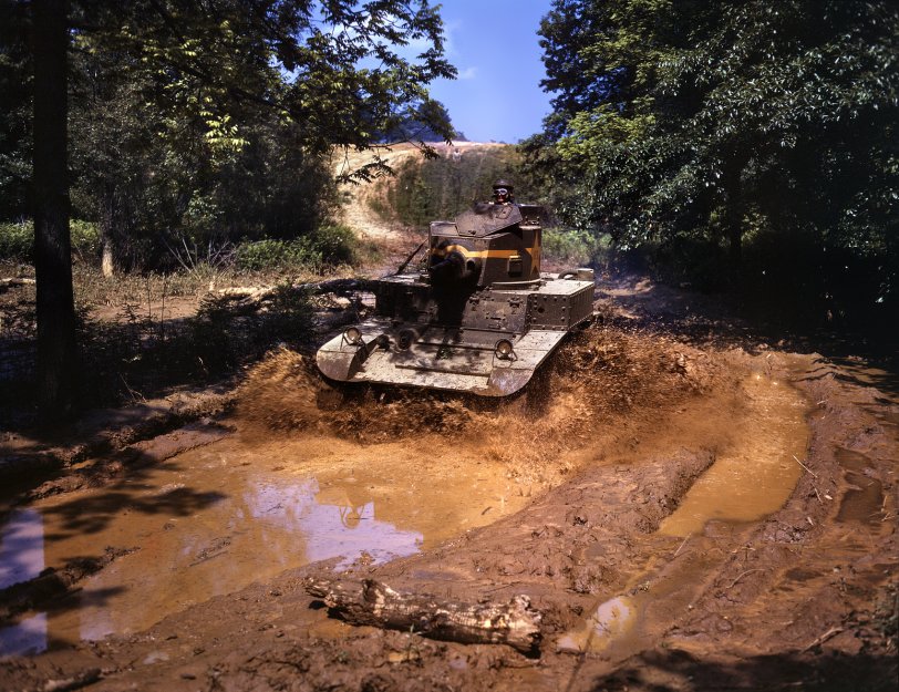
Nice pic of a Stuart going through the mud at Fort Knox, 1942.
Big version that and some dusty Grants going through their paces too.
-
Printing boo boo by a pirate? Argh!
-
Why doesn't battlefront.com just warehouse all the scenarios? Seems logical to me.
-
Wow that is gamey.
-
If you already hit the Go button, no. Your arty is committed and you can't recall it. You get that as a warning when order preparatory bombardment.
-
Not a silver bullet, but it is free. Sometimes you get what you pay forOriginally posted by Philippe:It's pretty good, a bit like Dr. Johnson's dog walking on two legs. I'm sure with time it will be an amazing resource, but for the moment my money's still on French hiking maps.

-
Certainly has been a lot of change. Even with just simple things like suburban sprawl. What were rural engagements in the 40's are now smack dab in built up areas. But moving mountains is hard. A lot of topography is going to be constant.Originally posted by Philippe:That's a really great resource for the contour lines.
But never forget that there's been more than half a century of furious change to most of the topographical features, so when you're putting together a map from the 1940's it's a bit like being an archeologist.
So you still need to look at old maps and aerial photographs for things like forests, hints as to which (if any) of the roads were paved, locations of old buildings, etc. And never forget that old maps of the Soviet Union often contained deliberate errors.
Having said that, I'm off to see if I can get Google to do a topographical map at 1:10,000.
But as you say, there are exceptions. I thought about doing a US 30th ID scenario for their night attack against Altdorf. I had the unit history, aerial photos taken right before the attack, and a translated German POV. I go to google maps to see what it looks like today, and it's not there. A little sleuthing and I figure out it's not there because a giant strip mine has wiped it, and alot of other little German towns, off the map. So sometimes they do move even mountains.
-
Finally, I've found topo maps for any scale, for any place (ETO, Italy, East Front, North Africa). Scenario designers no longer have to guess or interpolate from flat maps. No more obscure Italian geographic society maps to crunch through.
Here's Cassino:

To use these maps:
1. Go to maps.google.com
2. At the top of the left navigation bar, select the "My Maps" tab.
3. After the refresh, again at the top of the left navigation bar, select the "Browse the Directory" link
4. In the search box, type "elevation"
5. Select "Elevation Countours" NOT earthtools.org because the latter does not show contours for all locations.
6. On the new window, click the "Add it to maps" button
7. In the new window, upper left hand corner, click the "Back to Google Maps" link.
8. Enjoy
-
Thanks for the reminder. I checked it out, but it's still skimpy. Six scenarios (5 Brits, 1 Ami); mostly fictionals. Considering the strategic consequences and the see-sawing tactical events, I still think Salerno is overlooked in general.Originally posted by Philippe:You might want to take a look at the CMAK section of CMMODS and check out the zips of Sorted Scenarios. ...
And who wouldn't be interested in a scenario based on this guy, the pre-Audie Murphy Audie Murphy,

awarded the CMOH for actions at Altavilla and sent on a homefront publicity tour during the war.
-
I'm slowly but surely up to Operation Diadem and the Anzio breakout. Still stellar in terms of the writing, except for two minor critiques. Atkinson should give his thesaurus a rest (too many oddball words), and for all the maps he has it would have been nice to have one that showed Anzio in relation to Cassino and Diadem.
And the word Salerno is not found anywhere at the Scenario Depot. Nor Avalanche. Using google anyway.
-
Cool. I've added it to my CMAK Google Map
-
Ha! That's a good one. Whenever the briefing tells you that it's a good one. You know it's a well crafted briefing when it has a nice dose of that eternal oxymoron "military intelligence."Originally posted by jwatts:...and have been told the enemy Fallschirmjaeger have little AT defense, and certainly no armor of their own."
-
I'm in step with Philippe. I'm up to November 1943 and engagement with the Winter Line. Pretty good so far. I appreciate all the endnotes and sources Atkinson provides. I recommend it.
I wouldn't mind one or two Salerno scenarios to come from this. There aren't any Salerno scenarios as far as I've found.
-
...oh and catch the Raiders of the Lost Ark reference while your gaping at this Robot Combat Video
-
A modern example (let's say post-Industrial Revolution) would be helpful for Cuirassier's essay.Originally posted by Sixxkiller:Lust for power or to deny power to someone else is the cause of war. All ideaology such as money, resources, expansion, nationalism, etc... are just bi-products.
-
Economics. See Mein Kampf, Hitler's economic treatise why Germany must expand to the east to seek resources. In his mind expansion to the east was similar to the overseas colonies of UK and France. Germany could never acquire on overseas colonial empire, so she had to look east and colonize the Slavs. He certainly dressed it up with a thorough anti-semitism (i.e. nationalism), but the whole point in subjugating/eliminating these peoples was so that Germany could take their resources and prosper economically.
The American Civil War was certainly economic as well. The South seceded in order to preserve their slave based economy. Without their slaves, they feared collapse of their non-industrialized, agrarian economy. The South didn't fight for southern pride, or because they hated black people. They saw slaves as property (i.e. an economic resource) and the foundation of their economy.
The current war in Iraq? I don't know. That baffles the mind. Do the Sunnis and Shia fight out of nationalism/ethnic reasons, or are they fighting to see who gets control of Iraq's oil; to the winner gets the spoils? What is the U.S. doing there? Pursuing a national enemy or trying to pacify an economically vital region?
You can get more creative with your answer and say that national leaders take their countries into wars for economical reasons that benefit the wealthy, but use nationalistic reasons to motivate their lower-classes to fight and be soldiers despite not benefiting economically themselves. What are the self-interests and how do you compel people to fight when it's not in their self-interest?
-
Here's a link to a CMBB google map started by another BoB member.
-
Or check out any city today on my CMAK Scenario Google map CMAK Scenario Google map with info on almost 200 CMAK scenarios.
-
Hey David I, are you in here?
My CMAK Google Map project is up to 100 scenarios. I've captured all the scenarios that come on the CMAK game CD, and now I want to capture all the scenarios on your CMETO pack.
Each location on my map includes a hyper-link to where the scenario can be downloaded, but the CMETO ones have me perplexed. Should I link to this thread at battlefront.com, or are there better places to download the CMETO scenarios.
Check out HSG N Barkmann's Corner for an example of how I did one CMETO scenario. Right now, that's the westernmost Normandy scenario on the CMAK Google Map
-
Check out this CMAK Google Map I've put together. It has 100 scenarios on it, and is a cool way to find scenarios. The scenarios are also listed alphabetically in the left navigation bar. Each location contains basic scenario parameters and links to where the scenario can be downloaded. I think it's fun to zoom to the lowest level of a sat photo and check out the RL terrain or town.
Getting to 100 took less than 2 months. I think there are about 600 scenarios from the main sources (SDII, Boots & Tracks, etc.) Some CMAK scenario designers have started to help me out by sending latitude & longitude for their battles, and this certainly speeds things up.
I plan on having the map up as long as yourgmap.com hangs in there, so go ahead and bookmark my CMAK map.
-
This ftp link should work. Click it and choose to save file.
-
The file is ready. If you want a copy, just e-mail bmeyer1 (at) comcast (dot) net. I'll send it out to you. I'm supposed to have an ftp capability through my isp, but can't get it to work.
Lessons learned documents and staff studies
in Combat Mission: Afrika Korps
Posted
This one's good too: https://www.infantry.army.mil/monographs/content/wwii/index.htm
It's the Maneuver Center of Excellence Libraries Donovan Research Library World War II Collection. Mostly student papers from the late 40's at Benning. The students mostly wrote about their own WWII experience and analyzed the events for lessons learned.